Thursday, February 28, 2013

Maps and Boardgames (Part 4 - Creating a simple game)


After several months since part 3 I've decided to pick up my experiments and make a simple game out of them. "Why?" you may ask. Well, mostly because a friend of mine challenged me to, as his company, IBT, is promoting a contest for their core technology: xRTML.  Also, I thought it could be a fun experiment.

xRTML is a technology which allows developers to easily add real-time features to their websites and applications. It works flawlessly and is freaking fast. Hence should be a perfect match for any multiplayer web-based game in real-time, like the one I'm showing here.

So, what's the idea?

I wanted to do something very simple. Basic rules, player opens the browser and immediately starts to play.


URL: http://psousa.net/games/xrtml

Tuesday, February 5, 2013

Displaying WebGL data on Google Maps

Off-topic:
I haven't really payed too much attention to my blog lately. A mix of several projects have kept me occupied and without much time to write. Anyway, I've got some posts on the "pipeline" and I'll try to make up for the lost time :)


On-topic:
Recently I watched a video from the Google Maps Team (don't remember the link, sorry) were I was blown away by a demo using WebGL on top of a map. Basically it displayed thousands and thousands of points on a map without any performance hit whatsoever. I was very interested in exploring the demo and fortunately the Google lads were nice enough to create a simplified version of it inside the Google Maps Utility Library.

You can view this demo directly from the library repository here.


So, I'll begin by editing this example to show the same information set that I used in a previous blog-post, particularly one about using Canvas to display thousands of points in Bing Maps (link).


Basically it contains all the localities of mainland Portugal (about 140.000 points) and should be a nice test for this technology.

The canvas version fared itself quite nicely, but I expect the webgl to perform much better.


Sunday, November 4, 2012

Zoomable image with Leaflet

Last week the European Southern Observatory (ESO) published a 9 giga-pixel image cataloging 84 million stars in the Central parts of the Milky Way. They even provided this image in a zoomable format at http://www.eso.org/public/images/eso1242a/zoomable/ .

It's really cool, but I'm not particularly fond of the Flash Plugin that they've used. It's a little bit slugish, and IMHO something like Google/Bing/Leaflet could provide a much better user experience.

That said, here's what I'll do: I'll get a smaller image from ESO, split it in tile images and display it on Leaflet.

To split the image I'm going to use an utility called GDAL2Tiles. I'll show two variants of this:
  • using the command-line tool
  • using a Graphical Interface called MapTiler
If you just want to keep things simple jump right ahead to the MapTiler version. I'm also showing the command-line version because it's more productive and suitable to batching scenarios.

Wednesday, October 24, 2012

NHibernate Spatial (Part 5 - NHibernate 3.3.1+)


NHibernate Spatial is sort-of moribund, which is rather unfortunate because it's a really great project with lots of potential. Anyway, not conformed with it I decided to put the sucker onto Github to create an unofficial working version of it.

Fortunately some lads had the same idea avoiding me the extra-work. Unfortunately their projects don't have that much activity and most don't seem to really work. Anyway, in the spirit of GitHub and collaboration I decided to fork one of these to try my luck. Also, if time permits, I'll try to maintain it for future NHibernate releases.

I've forked the following project: https://github.com/suryapratap/Nhibernate.Spatial. The author already set it up nicely, making the following changes to the broken nhcontrib version:
  • Fixed compilation errors
  • Used NuGet for some references
  • Upgraded the projects from VS2008 to VS2010
So, props for suryapratap for providing a much nicer starting point. My own fork is at: https://github.com/pmcxs/Nhibernate.Spatial where I'm going to update this library.

Friday, October 12, 2012

Going the micro-ORM way with Dapper

If you're a developer you've most certainly used stackoverflow (or any other of the stackexchange sites). It's the reference Q&A site out there and has got tons of helpful content and a really enthusiastic community.

One of my favorite things about Stackoverflow is that it's damn fast. The interface, although minimalistic, shows lots of information, refreshes everything on-the-fly and just feels snappy. It's public knowledge that Stackoverflow developers are obsessed with performance, and fortunately they've been more than happy to share their secrets with the community through some blog posts and videos.

To achieve the results you see today they've used many clever tricks and tweaks, but have also developed some in-house tools to overcome the performance limitations of existing technologies. In this post I'm going to look at their own ORM: Dapper, which is widely used in Stackoverflow and has been open-sourced on Github (link).

Friday, September 7, 2012

OpenStreetMaps

I haven't blogged yet specifically about OpenStreetMaps (OSM). On this post I'm going to talk a little bit about OSM and the easiness and importance of adding information.

For those that haven't heard about OSM the simplest explanation is: it's the Wikipedia for maps. A joint collaborative effort of thousands of people to create a free world map.

Recently OSM has gained a lot of traction, mostly because of the transition of some key players from other mapping technologies/data to OSM. Notable examples:
  • Foursquare
  • Apple
  • Wikipedia
  • Craigs List
I'm really glad that OSM is finally getting the exposure that it deserves, but I still feel that it's a niche thing. Everyone that likes maps obviously knows it, but it isn't as entrenched on our web culture as something like Wikipedia, and most people don't realize that there's a free mapping wiki where everyone can contribute with unique and valuable information.

Friday, August 31, 2012

Freehand drawing with Cocos2d-x and Box2d

After going on holidays and recharging my batteries I'm ready for some more blogging action.

This will be a fun one. Basically I want to:
  • Allow the user to draw a freehand shape on the screen
  • After releasing the click/gesture the shape should materialize itself into a dynamic physics body.
  • The generated bodies should be affected by gravity and will collide with each other
I'll be using cocos2d-x 2.0.1 with Box2D for the physics.

(Update: 24 March 2013: As some people were having trouble making it work I've replaced the current download with a complete XCode project using the latest Cocos2d-x version (cocos2d-x 2.1.2))

Anyway, a video is worth more than 10.000 words (heck, if a picture is worth 1000 words a video is certainly more). Here's the final effect:


Monday, July 23, 2012

C++ revisited

During my academic and professional life I've been in touch with lots of different programming languages, for example:
Pascal, C, C++, Prolog, Java, Lisp, Javascript, C#, Smalltalk, and many others.

With time I lost contact with most of them, except C#, Java and Javascript.

Recently, as explained in my blog, I began to delve onto mobile game development using C++, mostly because it's a supported language in most mobile operating (iOS, Android and Windows Phone 8), and the "El Dorado" of being able to develop once and run everywhere (sort of).

Saturday, July 14, 2012

Custom Map Tiles (Part 5 - offline maps on iOS)


In this post I'm going to create an iOS mapping application, with the added benefit of using my own map tiles served offline, i.e, deployed with the application without requiring network connection.

I'm going to use a library called MapBox-ios-sdk and the tiles will be created using TileMill and served in the .mbtiles format.

Thursday, July 5, 2012

Load-Testing ASP.NET MVC (Part 3 - JMeter (slightly more) advanced)

Part 1 - Apache Workbench
Part 2 - JMeter introduction
Part 3 - JMeter (slightly more) advanced

As promised, in this post I'm going to explain some more JMeter stuff. So, I'll show how to:
  • Submit information (HTTP POST)
  • Handle authentication
    • Particularly in the ASP.NET MVC context
  • Read information from a page and store it in a variable
    • Particularly to read the ASP.NET MVC anti-forgery token
  • Vary the posted data by reading it from a CSV file
Also, I'll include some extra elements to make the test more maintainable and professional.

So, again, lots of ground to cover so lets get started.

Thursday, June 28, 2012

Load-Testing ASP.NET MVC (Part 2 - JMeter introduction)


Although Apache Workbench provides some simple and useful metrics it's a little bit limited. In this post I'm going to talk about a much more powerful tool for load-testing: JMeter (also from the Apache Foundation).

I'll start by replicating the previous experiment that I did with Apache Worbench but using JMeter, and gradually adding more complexity to it.

Saturday, June 16, 2012

Load-Testing ASP.NET MVC (Part 1 - Apache Workbench)


Performance is a critical aspect of most applications. Everything may be pretty, really well developed, intuitive and all, but if the performance is not up to par the user experience is going to suck.


Unfortunately most of these performance problems only show themselves after some time in production, making them much more cumbersome to solve and handle.

In this post I'm going to talk about something that should, IMHO, be integrated in the development lifecycle before the application goes live: Load-tests.

Thursday, June 7, 2012

Custom Map Tiles (Part 4 - Programmatically with EF 5)


Hi,

After a pause from mapping related stuff, I couldn't resist going back for some more, especially having just downloaded Visual Studio 2012 RC1.

In this post I'm going to show how to create tiles programatically at server-side using .NET 4.5 and Entity Framework 5 RC 1.

I'll basically create an ASP.NET MVC 4.0 application which handles http tile requests, uses Entity Framework to fetch spatial data from a SQL Server database and produces a bitmap image using GDI+. Then I'll show these tiles on a Leaflet Map. This seems too much trouble for what is worth but sometimes you just need the extra control to do stuff that otherwise would be really difficult to do.

As usual I'm going to show most of the steps to get this thing working, just jumping some hoops on simpler stuff. Anyway, even if some steps seem less clear I'm including a zip file with the whole solution.


Saturday, June 2, 2012

Create 3D objects inside Cocos2D-x (Part 2 - Menus)

Part 1 - Introduction
Part 2 - Menus

In my previous post I've created a very rough experiment showing some 3D boxes on top of the default Cocos2d-X template.

In this post I'm going to create something a little bit more useful: a level selection mechanism in 3D. This demo uses some additional concepts like:
  • Texturing
  • Changing the POV (Point-of-view) based on the device accelerometer
  • Click-detection
When launching the application we have the following screen:


Saturday, May 19, 2012

Create 3D objects inside Cocos2D-x (Part 1 - Introduction)

Part 1 - Introduction
Part 2 - Menus

Cocos2D-x is, as you might infer from its name, a 2d gaming library. But, as it uses OpenGL internally to draw its stuff, we might leverage it to create some 3D objects on the mix.

In this post I'm going to show how to create a  bunch of animated 3D boxes inside a Cocos2D-X scene mixed with 2D sprites.


Although I don't recommend using Cocos2D-x for making a complete 3D game, adding some 3D objects might bring some interesting effects.

Tuesday, May 15, 2012

Video Tutorial: Scrollable layer with Parallax (LevelHelper + Cocos2d-X)

A nice game level selection mechanism, particularly for "world" selection, is a scrollable layer that snaps to specific points. Also, I want to mix this with a parallax effect.

I've created a video tutorial that shows how to create this effect using LevelHelper, SpriteHelper and Cocos2d-x. Don't mind the sucky minimalistic "art" :)

It's my first video tutorial ever, so keep your expectations moderated :P


Tuesday, May 8, 2012

Mobile game development - The road so far


I've loved gaming since my first Spectrum in 86. Although I don't play as much as before I still try to find the time for some Skyrim, Battlefield, Uncharted, etc.

Anyway, that's the "consumer" side of it. Some months ago I started to delve into game development, particularly on the mobile space. As I had just bought a Mac I decided to target iOS.

Long story short, this has been the road so far:
  • Bought a Mac
  • Enrolled in a Apple Developer Program (meaning, paid 100 usd)
  • Stared at XCode and ObjectiveC scratching my head
  • Researched
  • Tried to develop a game
  • Failed miserably
  • (paused 6 months)
  • Re-Research
  • Current Time

Saturday, April 28, 2012

Parsing UTFGrid data to polygons

I've talked previously about UTFGrid. It provides, as described by Development Seed, "a standard, scalable way of encoding data for hundreds or thousands of features alongside your map tiles".

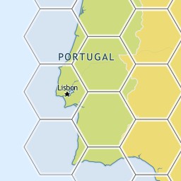
So, to sum it up, if we have this image tile for the hexagons of one of my previous posts.


We would have a corresponding json file with this UTFGrid
         !!!!!!!!!!!!!!!!!###################$$$$$$$$$$$$$$%%
            !!!!!!!!!!!!!!!!####################$$$$$$$$$$$$$$%%
             !!!!!!!!!!!!!!######################$$$$$$$$$$$$%%%
             !!!!!!!!!!!!!!######################$$$$$$$$$$$$%%%
             &&&&&&&&&&&&&&######################''''''''''''%%%
            &&&&&&&&&&&&&&&&####################''''''''''''''%%
            &&&&&&&&&&&&&&&&&###################''''''''''''''%%
           &&&&&&&&&&&&&&&&&&##################''''''''''''''''%
           &&&&&&&&&&&&&&&&&&&#################'''''''''''''''''
          &&&&&&&&&&&&&&&&&&&&################''''''''''''''''''
         &&&&&&&&&&&&&&&&&&&&&&##############'''''''''''''''''''
         &&&&&&&&&&&&&&&&&&&&&&##############'''''''''''''''''''
        &&&&&&&&&&&&&&&&&&&&&&&&############''''''''''''''''''''
        &&&&&&&&&&&&&&&&&&&&&&&&############''''''''''''''''''''
        &&&&&&&&&&&&&&&&&&&&&&&&((((((((((((''''''''''''''''''''
         &&&&&&&&&&&&&&&&&&&&&&(((((((((((((('''''''''''''''''''
          &&&&&&&&&&&&&&&&&&&&&(((((((((((((((''''''''''''''''''
          &&&&&&&&&&&&&&&&&&&&((((((((((((((((''''''''''''''''''
           &&&&&&&&&&&&&&&&&&(((((((((((((((((('''''''''''''''')
           &&&&&&&&&&&&&&&&&&(((((((((((((((((('''''''''''''''')
            &&&&&&&&&&&&&&&&((((((((((((((((((((''''''''''''''))
             &&&&&&&&&&&&&&&((((((((((((((((((((('''''''''''''))
             &&&&&&&&&&&&&&(((((((((((((((((((((('''''''''''')))
             **&&&&&&&&&&&&(((((((((((((((((((((('''''''''''+)))
             ***************(((((((((((((((((((((+++++++++++++))
            ****************((((((((((((((((((((++++++++++++++))
           ******************((((((((((((((((((++++++++++++++++)
           ******************((((((((((((((((((++++++++++++++++)
          ********************((((((((((((((((++++++++++++++++++
          *********************(((((((((((((((++++++++++++++++++
         **********************((((((((((((((+++++++++++++++++++
         ***********************(((((((((((((+++++++++++++++++++
        ************************((((((((((((++++++++++++++++++++
        ************************(((((((((((,++++++++++++++++++++
         ***********************,,,,,,,,,,,,,+++++++++++++++++++
         **********************,,,,,,,,,,,,,,+++++++++++++++++++
          ********************,,,,,,,,,,,,,,,,++++++++++++++++++
          ********************,,,,,,,,,,,,,,,,++++++++++++++++++
           ******************,,,,,,,,,,,,,,,,,,++++++++++++++++-
            *****************,,,,,,,,,,,,,,,,,,,++++++++++++++--
            ****************,,,,,,,,,,,,,,,,,,,,++++++++++++++--
             **************,,,,,,,,,,,,,,,,,,,,,,++++++++++++---
             **************,,,,,,,,,,,,,,,,,,,,,,++++++++++++---
             ..............,,,,,,,,,,,,,,,,,,,,,,////////////---
            ................,,,,,,,,,,,,,,,,,,,,//////////////--
            .................,,,,,,,,,,,,,,,,,,,//////////////--
           ..................,,,,,,,,,,,,,,,,,,////////////////-
           ...................,,,,,,,,,,,,,,,,,/////////////////
          ....................,,,,,,,,,,,,,,,,//////////////////
         ......................,,,,,,,,,,,,,,///////////////////
         ......................,,,,,,,,,,,,,,///////////////////
        ........................,,,,,,,,,,,,////////////////////
        ........................,,,,,,,,,,,,////////////////////
        ........................000000000000////////////////////
         ......................00000000000000///////////////////
          .....................000000000000000//////////////////
          ....................0000000000000000//////////////////
           ...................00000000000000000////////////////1
           ..................000000000000000000////////////////1
            ................00000000000000000000//////////////11
            ................00000000000000000000//////////////11
             ..............0000000000000000000000////////////111
              .............0000000000000000000000//////////22111
                          00000000000000000000000222222222222111

Thursday, April 26, 2012

Entity Framework 5 and Spatial Data (Part 2 - Comparison with NHibernate Spatial)

Part 1 - Introduction
Part 2 - Comparison with NHibernate Spatial

As promised in my previous post I'm going to do a comparison between NHibernate Spatial and Entity Framework.
 
I'll start by making a pros/cons list for both libraries, but just focusing on items that may differ between them.

 NHibernate Spatial

Pros:
  • True abstraction from the database with IGeoAPI/NetTopologySuite
  • Works with .NET 3.5 and newer
Cons:
  • No longer actively developed
  • Querying with LINQ/QueryOver doesn't work in many cases
  • Some spatial operators are not implemented


Entity Framework 5 Beta 2 Spatial

Pros:
  • Setup is a breeze
  • Querying with LINQ works flawlessly.
  • Natively integrated with Entity Framework
Cons:
  • The DbGeography/DbGeometry types belong to System.Data.Spatial. Therefore, we're always tied to the database model, even if just conceptually.
  • Requires .NET 4.5 (at least in the Beta 2. I don't know if support for 4.0 is on the road)

Wednesday, April 25, 2012

Entity Framework 5 and Spatial Data (Part 1 - Introduction)


I've blogged a lot on NHibernate Spatial. Although it works nicely, it seems to have been left for dead. It no longer compiles without modifying the source code and has many missing features and bugs.

On the other hand, Entity Framework is finally receiving native Spatial Support on version 5 (it's about time). Although it still is in Beta 2, I believe it's time to check it out and to see how it fancies itself. I'm going to create an example using it against a SQL Server database.

I'm going to use the following model:
  • There are 18 districts, each defined by a polygon
  • The are about 140.000 places, each defined by a geographic point
I've already used this model on a previous blog post.

I'll create two separate projects:
  • Class library with the model
  • Console application with some spatial operations